Seafloor geodetic evidence of slip deficit near the southwestern Kuril Trench
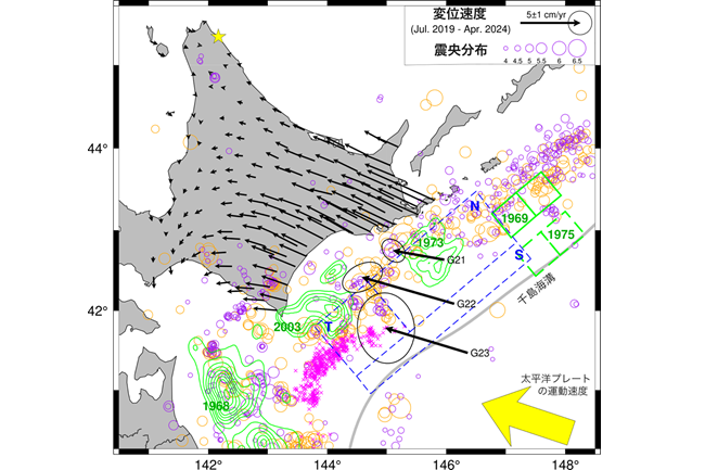
沖合の黒色ベクトルは、GNSS-A 観測点において得られた水平変位速度およびその2σ誤差楕円を示す。陸上の黒色ベクトルは、国土地理院F5解を用いて求めた陸上のGNSS観測点における水平変位速度を表す。黄色の星は、変位速度の基準点(北海道猿払村:950101 観測点)を示す。黄色のベクトルは太平洋プレートの運動方向・速度を示す。青色の破線の長方形は、17世紀の超巨大地震の断層モデル(Ioki & Tanioka, 2016)を表す。緑色の等値線は、過去の M7–8クラスの地震におけるすべり分布を示す。実線および破線の緑色の長方形は、それぞれ1969年および1975年の千島海溝沿いの地震の大すべり域を示す。紫色および橙色の円は、それぞれ観測期間である2019年7月から2024年4月まで(Mj ≥ 4.0)および観測期間以前の1997年10月から2019年6月まで(Mj ≥ 5.0)に発生した地震の震央を示す。マゼンタの×印は微動(Nishikawa et al., 2019)の分布を示す。
Joint press release (in Japanese) by Tohoku University, Hokkaido University and Japan Agency for Marine-Earth Science and Technology
Abstract
Understanding near-trench interseismic deformation at subduction zones is crucial for assessing the hazards of giant earthquakes, especially trench-breaking tsunamigenic earthquakes, such as the 2011 Tohoku earthquake. However, interseismic locking preceding such trench-breaking tsunamigenic events remain poorly constrained due to the limited sensitivity of onshore geodetic observations. Here, we present seafloor geodetic observations along the southwestern Kuril trench, a region with the potential for large coseismic ruptures reaching the trench, as inferred from historical tsunami records. Our results show high slip-deficit rates near the trench during…
Read more on Communications Earth & Environment
Article Information:
Fumiaki Tomita, Yusaku Ohta, Motoyuki Kido, Mako Ohzono, Hiroaki Takahashi, Ryota Hino, Takeshi Iinuma, Seafloor geodetic evidence of slip deficit near the southwestern Kuril Trench, Communications Earth & Environment, (2026)
DOI:10.1038/s43247-026-03297-2